


as in my actual vantage point.
one of the key things to finding a lost quarry is spotting key landmarks that are in the old photographs. if you can find and line up a landmark you can triangulate and locate a long age dig site.
so far my field work had kept me below hill level, and i was getting no closer to finding anything (or at least that's how it felt).
so i had an idea for today to see if i could change that.
 walking to the valley wall i decided to climb to the top. as this is the side of the badlands it has the highest perspective, and i hoped from up there i'd be able to see more of the valley's distinctive hills.
 that sounded easier than it actually was though. man those hills are deceptively steep!
it took me a little while to climb all the way up to the top.

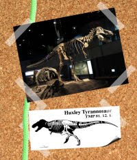
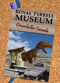
it was worth it for the view. for example this nice one of the tyrrell.
at the same time it turned out to be a total waste of time due to the view...
it turns out looking down into the badlands just doesn't quite help the problem.
when viewed from above all the hills end up looking the same. when you get below them and are looking up at the hill you have the sky behind them to notice details, and from you get a better idea of scale. from up on top of the valley the hills look more like mounds in a way, and you certainly can't tell them apart from each other easily.
so not so helpful afterall...

climbing down i thought i might as well talk about the very top layer of the valley while i'm up here. as typically i don't poke around this geologic unit, and nor was i likely too again anytime soon!

here is the top layer of the red deer river valley. the one above the green line, which you might remember from my 3rd palaeo challenge.
this "unit" (as the pros call it) is known as the glacial lake drumheller layer, and is the remnant of the mechanism that created the valley and the badlands in the first place.
two million years ago, in the neogene period, the ice age began and covered a lot of canada (and then later on part of the united states too) with ice. now i'm not talking about a little bit of ice. more like 2km thick sheets of ice as far as the eye could see (or not see, as would have been the case for under your feet)!
this huge amount of ice weighed so much, and moved with such power that removed huge amounts of sediment from the prairies (it was like a surface based tectonic plate!). this removal of layers cut down rocks laid down in the cretaceous which until then had been deep underground (of rocks laid down after the dinosaurs extinction)...
about 20,000-15, 000 years ago the glaciers had retreated to the north side of where the red deer river valley is today. the valley wall i JUST climbed would have been the edge of the ice (minus the erosion that has expanded the valley about a km since it was formed, but it is close enough for me to think that is cool)...
at this point in time, due to re increasing global temperatures, the glaciers were melting (slowly mind you). as of such they were producing a lot of melt water. some of this was trapped behind the glaciers ice, causing giant ice locked lakes...
(Production Note: Video from John Accorn's Adventures in Discovery)
eventual the wall of ice holding in this water melted, and let loose a WHOLE lake worth of water at once. naturally this caused a flood event, and that water needed somewhere to go! watch the video at this point to see what i'm talking about.
as there were no set drainage systems in place the water carved itself a new one... what you and me call a valley.
this cut into the prairies, cutting straight into the fossil rich layers of the cretaceous, which are present throughout most of alberta, but are underneath other layers (which again in the prairies the ice scooped off). meaning alberta has a unbelievably huge supply of fossils in it, most of it is buried deep beneath the surface... much like most places in the world, only we get lucky and have a few exposures of these layers in these glacial run off valleys.
 which as a story is cool. which if your a geologist is cool. which if your a dinosaur fossil hunter is uncool...
the reason being is that this top layer of fine yellow mudstone is about 64 980 000 years to recent to contain any dinosaur bone... or any other mesozoic era fossils. meaning if your looking for those sorts of fossils like me, this layer is useless!
not to mention unfun to get to... being so high up the hills!
 the glacial lake drumheller layer is not completely devoid of fossils mind you. all throughout this very recent unit are the shells of little fresh water snails that lived in the freezing cold lake (about the only thing tough enough to survive in the 4 degree water!). which are neat, but just don't enthrall me after a few, and certainly not worth the huge climb up the hill to find them.
besides i see enough of them while looking for fossils. some of them end up washing down the hill to the bottom of the valley, and you can find them along side equally eroded and washed out dinosaur bones...
anyways back to the prospecting trail i guess (as i can't use a drawing board in this case)...


3 comments:
You're right about the receeding (sp?) glacier and that glacier created the Great Lakes that cut the state of Michigan in half.
That reminds me of the Ice Age exhibits at the Museum of Natural History at Union Terminal, where they made a plastic, realistic replica of the glacier, and you can walk inside it. As soon as you get to it, there's a little exhibit of erosion, demonstrated by a staff member (though you can do it yourself.) Check it out when you're in the U.S.
Anyway, good luck, Traum. I KNOW you can find that quarry. I have faith in you, dude! You can do it!
Whenever we visit the highlands we get sights of similar sites in this country. Most of the time I read that the tropics were sort of a big "mini hothouse world" during the Ice Age and I think they seem to forget that we got the Andes and they change everything.
I remember having read about a canadian megalake that received the "visit" of a major comet during the Age.
if u were trying to find neat fossils then u should have talked to locals.i'm from drumheller and my son finds all sorts.when we have heavy rains all sorts of cool fossils get exposed.my son has t-rex (or some other predator)teeth that are like 4 inches long,serated and jet black.he finds all sorts of fossilised wood(even a complete fossilised stump)and some rocks that are full of clams.there is a hill in east coolee thats called tooth hill because everyone finds shark teeth there.and up river a bit theres a 25 foot shark semi exposed.nobody really tells the museum about their finds here but they are everywhere
Post a Comment